
Devil’s Marbleyard
- This is a long hike up a big hill but the view is fantastic and the place itself is marvelous. Truly.
- elevation gain is 1400 ft or so
- out and back hike is 3 miles
- if you want, once we reach the base of the Marbleyard, you have the option of climbing to the top to see where the whole thing started, enjoy the broader view, and delight in a half-hour of bouldering.
- we plan to be back by 1 PM on the dot 🙂
- You need to where stout shoes for trail hiking that may be wet in places, and optionally, scrambling up the boulders. I recommend hiking boots.
- You will need to bring at least a liter of water (in your reusable water bottle, right?) and layers of clothing. You will get hot hiking up, but it may be cool at the top and on the way down.
- If you tend to get hangry, bring a snack.
- Because of three and four, you’ll need to bring your backpack (minus its normal, heavy denizens like computers and textbooks–leave them in the lab if needed).
- Because we are doing this trip in a lab period, not a casual 5-6 hour day-hike, we need to be ready to leave exactly at 9 AM.
Be in your seat in the van when they leave at 9 AM.
Mass Wasting – Erosion due to gravity
- Read from Ch. 16 about “Mass wasting”
- What is a “landslide?”
- How does that different from a “debris flow?”
- Are they related?
- What causes landsliding ? (I am thinking physics here–and it isn’t well-explained in the textbook really)
- One related, but different question is: What are some events that trigger them?
- Here’s what the folks at Virginia Tech think triggered this slide.
https://www.youtube.com/watch?v=lD7KG5Ca_Bk
- Understanding paleoclimates: Have a brief look at some of the material in this site
https://globalchange.umich.edu/globalchange1/current/lectures/kling/paleoclimate/paleoclimate.html.- What are some of the types of evidence we can use to make a map like the one below?
- Look at this image of what vegetation was like 15-18ka.
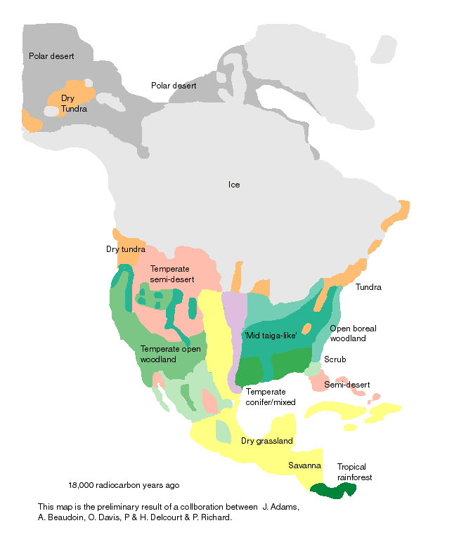
- from http://www.esd.ornl.gov/projects/qen/nercNORTHAMERICA.html where it also gives evidence it was drier here at that time.
- Google images for the terms “tundra” and “tiaga” used in the above landcover map. What was it like here in the Blue Ridge at this time?
- What are Milankovitch cyles and how do they relate to ice ages? (find some good info in your textbook about this too)
- When was the peak of the last “ice age” and when did end?
- What is permafrost? Do the annual freezing and thawing cycles under this kind of climatic condition create the potential for any erosion?
- How do your answers to 4 & 5 relate to questions 2 & 3?